- English
- French

News Releases
Power Ore Intersects 162 Metres at 1.01% Copper Equivalent at Surface At Opemiska
Toronto, Ontario – July 22, 2019 – PowerOre Inc. (“Power Ore” or the “Company”) (TSX.V: PORE) is pleased to announce results from drill holes 10 – 14 from its spring 2019 drill program at the Opemiska Copper Mine Complex in the Chibougamau District of Quebec.
Notable intersections include:
- 162.0 metres at 1.01% copper equivalent starting at 3.0 metres down hole in OPM-19-14, including:
- 2.21% copper equivalent over 62.7 metres
- 137.9 metres at 0.35% copper equivalent starting at 12.1 metres in hole OPM-19-13, including:
- 1.19% copper equivalent over 34.0 metres
- 0.73% copper equivalent over 14.8 metres starting at 19.2 metres down hole in hole OPM-19-11
*Copper Equivalent (“Cu Eq.”) grade including copper, gold, silver, cobalt and zinc based on 100% recoveries is calculated using the following equation: Cu Eq. = [(Cu % x 20 x Cu price) + (Au grade / 34.2857 x Au price) + (Ag grade / 34.2857 x Ag price) + (Co % x 20 x Co price) + (Zn % x 20 x Zn price)] / (20 x Cu price). We used Cu, Au, Ag, Co and Zn price of US$2.65, US$1,400 and US$14.75, US$15.00 and US$1.19 respectively.
“We are happy to report our best intersection to date with 162 metres of 1.0% copper equivalent in hole 14 with the mineralized zone beginning a few metres down hole. This is significant to the confirmation of our interpretation that solutions ponded and were deposited in a disseminated style at the contact between the Gabbro/Pyroxenite sill and underlying Rhyolite. This drill program continues to show extremely wide mineralized intersections near surface. Opemiska’s very high-grade veins are already understood, defined and remain intact with the pillars. However this drill program was specifically designed to give us information on mineralization outside these veins which is critical in our reinterpretation of Opemiska as an open pitable deposit,” said Stephen Stewart, Power Ore’s CEO.
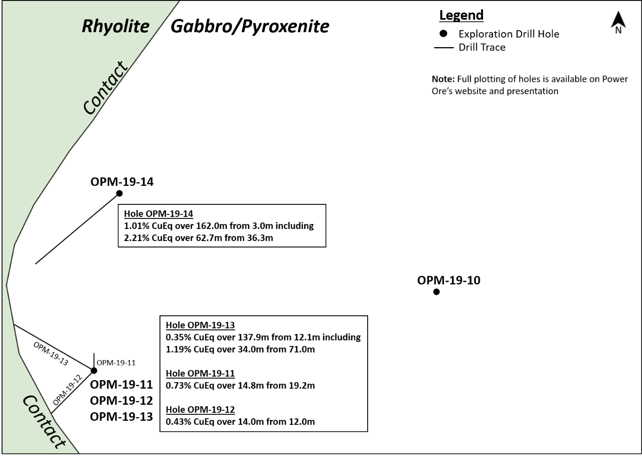
Figure 1) Map of Drill Hole Locations (Holes 10 – 14)

Click here for Map of Drill Hole Locations
Power Ore completed 23 diamond drill holes in this 3,364 metre drill campaign and will report the results for the remaining 9 holes as the Company receives them.
Summary Mineralized Intersections (Holes 10 – 14) From Opemiska Spring 2019 Drill Program
| Hole ID | Grade | Interval (m) | From (m) | To (m) | |||||
|---|---|---|---|---|---|---|---|---|---|
| Copper Eq (%) | Copper (%) | Gold (gpt) | Silver (gpt) | Cobalt (%) | Zinc (%) | ||||
| OPM-19-14 | 1.01 | 0.46 | 0.20 | 3.68 | 0.003 | 0.79 | 162.0 | 3.0 | 165.0 |
| INCLUDING | 2.21 | 0.91 | 0.42 | 6.52 | 0.005 | 2.00 | 62.7 | 36.3 | 99.0 |
| OPM-19-13 | 0.35 | 0.26 | 0.08 | 1.14 | 0.004 | 0.008 | 137.9 | 12.1 | 150.0 |
| INCLUDING | 1.19 | 0.91 | 0.28 | 3.47 | 0.006 | 0.02 | 34.0 | 71.0 | 105.0 |
| OPM-19-12 | 0.43 | 0.25 | 0.17 | 2.11 | 0.005 | 0.01 | 14.0 | 12.0 | 26.0 |
| OPM-19-11 | 0.73 | 0.48 | 0.25 | 4.49 | 0.003 | 0.02 | 14.8 | 19.2 | 34.0 |
| OPM-19-10 | No Significant Intersection | ||||||||
*Copper Equivalent (“Cu Eq.”) grade including copper, gold, silver, cobalt and zinc based on 100% recoveries is calculated using the following equation: Cu Eq. = [(Cu % x 20 x Cu price) + (Au grade / 34.2857 x Au price) + (Ag grade / 34.2857 x Ag price) + (Co % x 20 x Co price) + (Zn % x 20 x Zn price)] / (20 x Cu price). We used Cu, Au, Ag, Co and Zn price of US$2.65, US$1,400 and US$14.75, US$15.00 and US$1.19 respectively.
Hole OPM-19-14
Hole 14 was collared on the same set up as hole 01 but was drilled to the southwest to test along the edge of the Glory Hole and ended in rhyolite at 195.7 metres. The hole is well mineralized with current results to 165.0 metres and returned 1.01 % CuEq over this complete length starting at 3.0 metres and includes a 2.21 % CuEq interval of 62.7 metres starting at 36.3 and notably intersecting Vein #2. Assays are pending from 165.0 to the end of the hole and includes a mineralized intersection in the footwall rhyolite.
Hole OPM-19-13
Hole 13 was drilled to the south of the Glory Hole on the same setup as Hole 12 but was oriented towards the northwest to intersect the rhyolite contact near the Glory Hole. The hole ended in rhyolite at 195.7 metres. The hole intersected a wide interval of disseminated mineralization grading 0.35% CuEq over 137.9 metres starting at 12.1 metres and ending at 150.0 metres and this included a higher grade section of 1.19% CuEq over 34.0 metres starting at 71.0 metres and that included Vein #1. Below 150.0 metres the hole is visually less mineralized and assays are pending.
Hole OPM-19-12
This hole was drilled on the same setup as Hole 11 but was drilled to the southwest towards the contact of the rhyolite. The hole intersected 0.43% CuEq over 14.0 metres starting as 12.0 metres. Total hole length is 122.6 metres and the hole stopped in rhyolite. It is apparent that the contact is less mineralized in this area.
Hole OPM-19-11
Hole 11, drilled to the north, entered the Glory Hole stope (Vein #3) at only 37.9 metres and intersected 0.73% CuEq over 14.8 metres starting at 19.2 metres. This was the first of three holes on the same setup immediately south of the Glory Hole to test for mineralization near the contact with the footwall rhyolite.
Hole OPM-19-10
Hole 10 was terminated at 51.1 metres when it entered a stope of vein 34. Only minor mineralization was encountered in the hole.
Orientation of Drilling and True Widths of Mineralization
Field based and drill hole evidence clearly indicate that several orientations of veins are present on the Opemiska Property but that around the Springer Mine the veins are predominantly EW with a steep dip to the north. South directed drill holes are intersecting those veins near perpendicular. However in the disseminated mineralization we find veins with various core angles suggesting that other directions may be important. As such, in the disseminated mineralization the true width of mineralized intersections is estimated to be the same as the drill core width even though the mineralization may have an overall envelope that is different.
QP Statement
The technical information contained in this news release has been reviewed and approved by Charles Beaudry, P.Geo and géo., Director and Vice President Exploration for Power Ore, who is a Qualified Person as defined in “National Instrument 43-101, Standards of Disclosure for Mineral Projects.” For the exploration undertaken by Power Ore all assay batches are accompanied by rigorous Quality Assurance procedures that include insertion of standards and blanks and verification assays in a secondary laboratory. Quality Control results, including the laboratory’s own control samples, are evaluated immediately on reception of batch results and corrections implemented immediately if necessary. All drill collars are surveyed and positioned in UTM coordinates. Downhole deviations surveys are done with a Reflex instrument at 30m intervals. A systematic density measurement program using two methods was implemented to measure density of all rock types. A specific susceptibility measurement protocol was also implemented to better estimate the relative abundance of magnetite in the variably magnetic rocks of the Ventures Sill.
About Opemiska Copper Mine Complex
The Opemiska Copper Complex is located within the Chibougamau region. Opemiska is also within the Abitibi Greenstone belt and within the boundaries of the Province of Quebec’s Plan Nord which promotes and funds infrastructure and development of natural resource projects. The project consists of 11 mining claims and covers the past producing Springer & Perry mines which were owned and operated by Falconbridge. The project has excellent in place infrastructure including a powerstation and direct access to Highway 113 and the Canadian National Railway.
For information and updates on Power Ore, please visit: www.powerore.com
And please follow us on Twitter @PowerOre
To speak to the Company directly, please contact:
Stephen Stewart, Chief Executive Officer
Phone: 416.644.1571
Email: sstewart@powerore.com
Neither TSX Venture Exchange nor its Regulation Services Provider (as that term is defined in the policies of the TSX Venture Exchange) accepts responsibility for the adequacy or accuracy of this release. Certain information in this press release may contain forward-looking statements. This information is based on current expectations that are subject to significant risks and uncertainties that are difficult to predict. Actual results might differ materially from results suggested in any forward-looking statements. Power Ore is a trade name of PowerOre Inc. PowerOre Inc. assumes no obligation to update the forward-looking statements, or to update the reasons why actual results could differ from those reflected in the forward looking-statements unless and until required by securities laws applicable to PowerOre Inc. Additional information identifying risks and uncertainties is contained in filings by PowerOre Inc. with Canadian securities regulators, which filings are available under PowerOre Inc. profile at www.sedar.com.

